 Filter: Categories of Wisconsin Historical Images
Filter: Creator Name of Ogle, George A.
Filter: Categories of Wisconsin Historical Images
Filter: Creator Name of Ogle, George A.
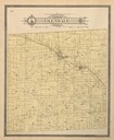
| Date: | 1897 |
|---|---|
| Description: | Plat Map of Glendale Township in Monroe County. |

| Date: | 1912 |
|---|---|
| Description: | A portion of a plat map of Marinette County showing township 30 N., range 21 E., and part of township 29 N., range 21 E. |
If you didn't find the material you searched for, our Library Reference Staff can help.
Call our reference desk at 608-264-6535 or email us at: